 Until well after WWII, Miami Beach was strongly segregationist. Known as the home of Good Millionaires as opposed to Palm Beach, the rallying point for Bad Millionaires, Miami Beach, in the '20s and '30s, attracted the likes of Harvey Firestone and J. C. Penney. WASP (White Anglo-Saxon Protestant) credentials were implicit prerequisites for acceptance anywhere above Fifth Street in addition to well established and massive
  wealth. Well-to-do also-rans, seemingly, had to be satisfied with the relative rigors of life in Palm Beach. As late as 1949, "No Dogs, No Jews" signs were to be seen in hotels lobbies and other pseudo-public areas while real estate advertising included memorable phrase such as "All views, No Jews". In the case of black visitors to the city, up through the early '50s, a pass showing proof of employment was required, even to cross the bridge. Mysterious then, that this should be the site chosen for a major Holocaust Memorial. WWII was instrumental in
 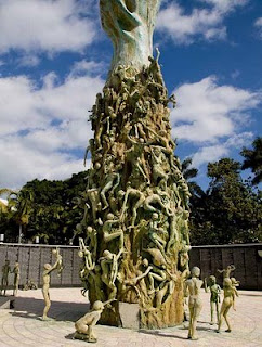 initiating changes in Miami Beach. With a massive influx of military personnel, plant and equipment, along with attendant support systems, a blurring of established social boundaries began, culminating in a more cosmopolitan landscape by the mid-fifties. Since then, South Beach has endured several other near-death experiences but survived them all. Vanishing vacationers in the 1960s and '70s led to rapid decay and significant slumming down of the area. A group of worthy citizens successfully halted this disaster by forming the Art Deco District preservation effort and revitalized visitor enthusiasm. This effort, in turn, was almost nullified by the Mariel Boat Lift in the early '80s which
 resulted in 125,000 criminals, mental defectives, hookers and other assorted undesirables being imported into the area from Cuba. Nice one, Fidel. The TV show Miami Vice is credited by some to have helped lift the area's image again in the mid '80s, as South Beach became a hot area for edgy advertising shoots, music-videos and other Hollywood fare. Meanwhile, the Jewish community had flourished mightily. Dade County
  was now home to 11% of the nationwide American Jewish population who, in turn, made up 12% of the entire county population. Thus it was, that a group of Holocaust survivors formed a committee in 1985 leading to the opening of the Memorial in 1990. The Memorial itself, has a curved walkway with a reflecting pool and a black granite wall from which a passage leads to a circular, walled plaza. The centerpiece of the plaze is a 42-foot bronze arm reaching up out of the ground and decorated with about a hundred life-sized bronze figures, some climbing the arm, some scattered about the plaza. A touch too bizarre, for my simple mind, to evoke much response beyond "Huh?" But then, each to his own.
 In a little over 100 years Miami, Florida grew from 300 people to 5-1/2 million, earning it the title of The Magic City with snowbirders since it seemed to grow magically with each passing year. The place to live of course, is Miami Beach which is confined to the narrow strip of land running down the Atlantic side of the intra-coastal waterway. Miami proper however, has some claims to fame of its
  own. Now the 4th largest metropolitan area in the USA behind New York, Los Angeles and Chicago and the 3rd ranked skyline behind New York and Chicago, Miami has grown into a true southern metropolis. Officially designated a Global City, it effectively fills the area from the Atlantic coast to the everglades along a 40 mile north-south swath. All that aside, downtown Miami is much like any other downtown and the suburbs are a sprawling melee of housing ranging from small, boxy post WWII homes to upscale additions with yuppie villas by the square mile. The only major US city to have been founded by a woman - Julia Tuttle, an early snowbird from Cleveland, incorporated the city in 1896 - its success assured when Ms. Tuttle convinced Henry
  Flagler to extend his railroad south to service the city. Scarily, the entire greater Miami area has a an elevation of just 6 feet above mean sea level. But, our objective was Miami Beach, across the intra-coastal to the southern end of the sandbar known as South Beach. Here is the largest assortment of Deco architecture in the world with almost every example maintained in pristine condition. Conjuring images of pastel colored cruise ships and Flash Gordon
  rocket ships, the Art Deco buildings, with their portholes, rounded walls, steely accents and geometric decorations, are simply awesome. The Art Deco form developed from the 1925 World’s Fair in Paris from a fusion of Art Nouveau and early twentieth century industrial modernism, although the term itself only came into use much later. If you like that sort of thing, click here.
When Frank McCloud (played by Humprhey Bogart) alighted from the bus in Key Largo during the opening scene of the film of the same name, the Overseas Highway,  as US 1 is known, had been operational for less than ten years. From the early 1910's until 1935, outside of a plane or a boat, Henry Flagler's Florida East Coast Railway was the only continuous route to Key West. The 1935 Labor Day hurricane put paid to this convenience in a heartbeat and it wasn't until 1939 or so that a continuous roadway was cobbled up from existing bridges and parts of the defunct railroad. This 127 mile, mainly two lane highway continues to have the highest accident rate per capita, in all of Florida.
Altogether, there are about 1,700 islands in the Florida Keys archipelago, divided into the Upper, Middle and Lower keys. The Saddlebunch keys are a series of mangrove islands in the Lower keys, about 7 miles east of Key West and it is here, on a tiny finger of land, that the Bluewater RV resort is located. See here for more Bluewater views. This particular RV park has 81 total sites, all of which are owned by individuals and, at the time of our stay, almost 25% (20 sites) of these were available as resales - some at quite distressed price levels.
So much for the keys - gone from our to-do list and is unlikely to make our do-again list. Lots of Florida tackiness with few offsetting benefits and, while lurking in the campground was both relaxing and comfortable, there was not more than two or three days of vigorous exploring within an hours drive. Been there, done that.
 Boca Chica Highway, County Road 941 used to run around the southern side of Boca Chica Key. The NAS airfield that now dominates this key was initially constructed in 1940 and, as it has grew and took over the majority of island, the destination for CR 941 was absorbed into the base. Except for the east end of the highway, that serves a surviving residential area, the road has been abandoned and much of it has been recovered by nature.
 Several miles of public right-of-way still run along the shoreline providing a rustic-junkyard quality of beach walk which, half a mile in, is posted "Warning - Clothing Optional Beach Ahead". It was here that we witnessed the true meaning of beach bum as we stumbled naiavely along while assorted buns, lurking in the undergrowth ahead of us, were hurriedly covered. Full story here.
 The Keys do not offer much in the way of shopping. No Wal-Mart, Sam's Club, Costco or elegant malls within 100 plus miles - just a few grocery stores, miles of tacky plazas, lots of bars and a smattering of restaurants. The upscale restaurants in Key West are more convenient than those in Miami a hundred and fifty miles away but are extraordinarily expensive. Such local offerings, at least those that we checked out, are far from stellar.
Ever optimistic, we decided on something different and perhaps, even a little romantic - a Dinner Cruise from which to enjoy a Key West sunset. What a tatty illusion this turned out to be. See sorry story here.
The English guys, Dave and Lynn - they of cool cooking  fame, have a Monaco Dynasty with the Nottingham floor plan. This was the actual coach that wooed us into changing out our Signature last year - all due to the Nottingham's great kitchen. Dave and Lynn sometimes travel with four or five people on board and had the kitchen modified to include an oven and a three burner stove top. An oven! What a joy. We haven't had an RV with an oven since 1991 and, apart from an incendiary episode with the convection microwave in our 2000
  Country Coach, we had put roasts and baking on the road, out of our minds. Now, at the first opportunity we baked some bread and the oven worked like a charm. Next stop was to check out the convection microwave and - Guess what? - it worked like a charm. These loaves were baked on low-mix at 425 for 25 minutes and turned out just right!
 As the weather got colder we kept driving south until there was no more south to go to and still it was cold! That, in a nutshell, is how we ended up huddled around the most southerly point in the lower 48 at the junction of Whitehead and South Streets in Key West, Florida.
While the Keys have always been on our to-do list, the 600 mile journey from the Georgia border through the customary wintertime Florida hordes, coupled with our innate laziness, have always provided ample reason for not bothering. This year however, circumstances ganged up on us and, outside of blatant wimpishness, we simply ran out of excuses. First, we were already at Lazydays having our coach brutalized - a full 1/3rd of the way to the end of the world. Next, some English folk we had met last summer arrived at Lazydays about the same time having booked a site in the keys for a couple of months or so. Finally, with the economy at large holding the populace in some kind of suspended animation, snowbirds were looking like an endangered species and the f ormerly "packed" vacation sites were all replete with vacancies. So, off to Bluwater Keys RV Resort it was!
We greatly enjoyed a couple of weeks lazing around with the Brits, swapping tall tales of the Old Country and petting their adorable 140 pound dog Peppa. Better yet, they turned out to be accomplished meal meisters and we had more cooked meals in two weeks than we normally see in a year! The Bluewater Keys site, chosen from England on a whim, was the best we encountered on the 120 mile ride along the string of mud-piles leading to Key West and, overall, the weather was 60 to 80 degrees warmer than Fort Wayne. All in all, a great trip. See memories of Key West here.
 Christopher Columbus, in 1493, is believed to have been the first European to come across the archipelago that includes what is now Tortola. With typical flair, he named the group Santa Ursula y las Once Mil Vírgenes (Saint Ursula and her 11,000 Virgins) after the legend of Saint Ursula, hence the Virgin Islands. Once squabbled over by the Spanish, British, French, Danish and Dutch as strategic possessions, the islands are now split between the British and the US who bought the few remaining Danish islands in 1917.
The British Virgin Islands (BVI) consist of more than fifty islands,
Christopher Columbus, in 1493, is believed to have been the first European to come across the archipelago that includes what is now Tortola. With typical flair, he named the group Santa Ursula y las Once Mil Vírgenes (Saint Ursula and her 11,000 Virgins) after the legend of Saint Ursula, hence the Virgin Islands. Once squabbled over by the Spanish, British, French, Danish and Dutch as strategic possessions, the islands are now split between the British and the US who bought the few remaining Danish islands in 1917.
The British Virgin Islands (BVI) consist of more than fifty islands, the largest of which, Tortola, contains the capital Road Town. Tortola is approximately 12 by 3 miles and is home to about 18,000 of the total 22,000 population. Although the entire region was a notorious haunt for pirates, the Brits introduced sugar cane which became the main source of foreign trade until the middle of the 1800s. BVI gained separate colony status in 1960 and complete autonomy in 1967.
Since the 1960s, the islands have diversified from an agricultural economy into tourism and financial services with the hugely popular International Business Companies Act, passed in the early 1980s, leading to massive growth in  government revenue. With more than 50,000 companies worldwide having an offshore presence there, the U.S. dollar is the official currency even though the Islands are under the British flag, and BVI residents are amongst the most affluent in the Eastern Caribbean. Affluence of course, is a relative term - the entire Eastern Caribbean exudes an air of abandonment from past Empires and Tortola is no exception. See here for more pictures.
 The hiatus between Thanksgiving and Christmas turned horribly cold in Indiana, motivating us wusses to flee to warmer climes. But where? The most immediate opportunity was a boat to the Antilles, so, without further ado, we left. Big plane to Miami, big boat to eastern Carribean and then sport our lovely legs in shorts for a week or two. Fabulous!
Columbus' first stop in the New World in 1492 was the island of Hispaniola
The hiatus between Thanksgiving and Christmas turned horribly cold in Indiana, motivating us wusses to flee to warmer climes. But where? The most immediate opportunity was a boat to the Antilles, so, without further ado, we left. Big plane to Miami, big boat to eastern Carribean and then sport our lovely legs in shorts for a week or two. Fabulous!
Columbus' first stop in the New World in 1492 was the island of Hispaniola and that was our first port of call as well. Hispanolia (from Spanish, La Española) is about the size of South Carolina and is the second-largest island of the Antilles with Cuba to the west, and Puerto Rico to the east. Today, the western third of the island is home to Haiti while the remainder has become the Dominican Republic. The ship stopped at the little city of Samana on the northeast corner. Click here for more pictures.
 Fria, farta, forte e feia, simply Cold, rich, strong and ugly goes the local Portuguese description for Guarda. A fortified town overlooking the Spanish border about 10 miles to the east, at 3,500 feet Guarda is the highest town in Portugal. Replete with narrow streets, defensive wall and a couple of surviving gates, the highest part of town sports a large square and one of the ugliest Gothic cathedrals known to man. Built in the 14th and 16th centuries, the interior is quite graceful with twisted pillars, arched vaulting and a Renaissance altar of white marble, gilded in the 18th century with 100 high-relief figures. Other churches within the city walls include t
 he Misericordia and São Vicente Church. Sights from around town can be seen here.
Formerly thought to have been a military base for Julius Caesar, then for the Visigoths and eventually for the Moors, modern Guarda was founded in 1199 by the second king of Portugal, Sancho I, has a population of about 31,000 and includes 55 parishes.
he Misericordia and São Vicente Church. Sights from around town can be seen here.
Formerly thought to have been a military base for Julius Caesar, then for the Visigoths and eventually for the Moors, modern Guarda was founded in 1199 by the second king of Portugal, Sancho I, has a population of about 31,000 and includes 55 parishes.
 2008 that is. Since Thanksgiving we have been in a maelstrom. Thanksgiving was at our place with all the US family except Air Force grandson in Wyoming and middle daughter slaving away in England. Turkey (or cook - me) was sub-standard but most everything got eaten anyway so I still claim it as a win.
Then the weather went really bad - cold, cold, cold, so we snuck off to the Caribbean for a while to hasten the onset of Christmas - blogs coming up.
2008 that is. Since Thanksgiving we have been in a maelstrom. Thanksgiving was at our place with all the US family except Air Force grandson in Wyoming and middle daughter slaving away in England. Turkey (or cook - me) was sub-standard but most everything got eaten anyway so I still claim it as a win.
Then the weather went really bad - cold, cold, cold, so we snuck off to the Caribbean for a while to hasten the onset of Christmas - blogs coming up.
Christmas was also at our place, this time with middle daughter but still without USAF grandson. Turkey was great and, after everything was eaten, everyone went home. Funny how that works. Pictures here for the bravehearted.
England daughter went back to the old country so we left town for the winter. So far, made it to Macon, GA but still have not escaped the winter - 31 degrees tonight, quite a hoot this far south to see the locals deal with such frigid times. Monday, the Lazydays' blacksmiths will continue hastening the entropy of our coach as they blunder their way through our punch list. Given that they get done before April we will be heading somewhere, otherwise we'll be heading home. At least there will be a chance to catch up on '08 blogs. Do have a GREAT 2009!
 Continuing with our 2008 trundle around Europe, we decided to head east from the Atlantic coast and the tawdry town of Barra and get back to Spain which, by now, had started to look quite attractive. About halfway across, on the A25 road, is the city of Viseu.
The Romans kept a 90 acre garrison on the hilltop that eventually  became Viseu. In the 6th century, the Suevi tribe of the Vandals drove the Romans off and installed a Catholic regime on the area. The Visigoths, in turn, frightened off the Vandals in the 7th century but shortly thereafter, were themselves ejected by the Moors.
The Moors hung in until the 12th century when King Alfonso V of León drove the Moors away and annexed the area into the County of Portucale. Later, when Dom Afonso invented the Kingdom of Portugal, Viseu became part and of it. Check out a few of the local sights here.
European camping is so very different from the leisurely, made in the shade luxury we enjoy here in the US. It's not that it's bad, it's just different. Check out some of the "sites".
 About halfway down the coast of Portugal there is a large sand bar that forms a complex of intra-coastal waterways. In 1932, the Big Cheese of Portugal, Presidente da Republica General Antonio Oscar de Fragoso Carmona Iancou, solemnly laid the first stone of a monument commemorating the development of the area. Subsequently Praia Barro (Barro Beach) and Costa Nova (New Coast) grew into laid back communities of low cost housing. In the last few years however, everything has changed - this rustic area was "discovered" and quickly sprouted high rise holiday homes and yuppie cafes while the waterways filled with leisure boats and the low cost houses were tarted up to imitate holiday homes. Each to his own. Additional scenes from paradise here.
 Our Coimbra day was one of those occasional days when we should have stayed in bed. "Big Cityed" out, horrible humidity, on and off rain and no possible chance of parking near the good stuff all combined to render a unamimous decision for a short visit. We took a slothful stroll along the river, rubbernecked a while and left.
Coimbra is the seventh largest city in Portugal and is number seven of just eight cities that have a population over 100,000. The University of Coimbra, with 23,000 students on campus, many of them international, was founded in 1290 and is the oldest academic institution in Portugal and one of the oldest in Europe. A further 12,000 students attend other higher education institutions giving the town an energetic and cosmopolitan atmosphere.
The city contains important archeological remains, including a well preserved aqueduct, from the time when it was the Roman town of Aeminium. Built on a hill near the river Mondego, Coimbra is located near the Atlantic coast, 70 miles south of Porto, 120 miles north of Lisbon  and about 25 miles inland. Around 600 CE, the Visigoths kicked the romans out before being vanquished themselves by the Moors in 711. Five hundred and fifty years later, in 1064, Ferdinand I of León booted the Moors out - score one for the Christians!
Several extant monuments such as the Old Cathedral, the Church of St. James and the Santa Cruz Monastery date back to the period commencing with Ferdinand I. Some remnants of the original city wall fortifications are stll visible. Lots of great sights in Coimbra from all reports - kinda sorry we were not more up to the challenge.
 For the last couple of years we have been fortunate to have had the use of a UK based European camper van (RV) for several months. All told, between the spring of 2007 and the summer of 2008, we spent more than a third of a year traveling the highways and byways of about 20 European countries and visiting more than 100 camp sites. The only problem we've encountered to date, is that the experience is habit forming
 - so much scenery, so many historical sites, so much cuisine, so many shopping adventures and all this in a variety of languages.
The question then became "How to organize to be able to make such visits on an as required basis". Some research and a little luck produced a possible answer - "Turner Cars and Campers" in Utrecht, NL, so off to Utrecht we went. To make a long story short, after verifying how the plan works we scouted around for a suitable vehicle and quickly became the impoverished owners of a mobile holiday home in Europe. See here for pictures of "Ons Huis". Europe anyone?
 After a frigid day in Harwich we felt in need of a little coddling, perhaps even a lot of coddling. Our expectations of a cabin on the ferry had not been high and included greasy metal grid floors, rusting communal toilets, fishy smelling corridors and indescribable galley food.
What a pleasant surprise then, that the Stena Line ferry turned out to be a mini cruise ship. Comfortable room, crisp linens, large private bath and shower, great shopping and two restaurants serving delicacies such as Steak Pie and Fries swimming in Gravy - Mmmm. Thus was our need for pampering sated.
Next morning we woke in Holland, left the ferry and took a train into Rotterdam. There we picked up a car and set off into the hinterland. Although the focus of our visit was Utrecht we actually spent little time there, instead we ran around all over the local countryside and spent a whole lot of time looking for vacant hotel rooms - the whole place seemed to be buzzing.
We did visit a little place called Harderwijk a couple of times and managed a quick walkabout. See here for more of this Dutch treat.
 Bright and early on Friday, we boarded a bus to Liverpool Street Station in north east London, from which trains serve the 2 o'clock sector of England, known as East Anglia. About an hour and a half later, during which we reached speeds of 92 mph, we alighted in Harwich and were chastened by cold, windy and wet weather. Brr.
 Harwich is a threadbare coastal town in the county of Essex, that provides the only significant protected anchorage on the North Sea coast between the Thames in the south and the River Humber in Yorkshire. The town received its charter in 1238, became a naval base in 1657 and was fortified with the Harwich Redoubt and a couple of coastal batteries in 1808, to ward off possible attack during the Napoleonic War.
  At one time an important port, Harwich, like the ports of London, was left behind by containerization and now has little more than a struggling ferry terminal. It is highly-regarded in architectural circles and is mostly under protection as a conservation area.
Some buildings of note include the parish church of St. Nicholas and the Guildhall of 1769, the only Grade I listed building in Harwich. The Pier Hotel of 1860 and Great Eastern Hotel of 1864 (now an apartment block) both grew out of increased traffic after the railway arrived in 1854. Click here for more.
 "The City" covers just about 1 square mile. This is pretty much the area walled in by the Romans in the 2nd century to protect their port and, with a small deviation here and there, the original wall line still defines the city. Prior to 1666 with its Great Fire, the area fairly bristled with churches - more than 100 of them, 97 of which fell within the walls. The fire destroyed 89 of these and, after much debate, just 51 replacement churches were rebuilt, mostly by Christopher Wren.
Totaling these with new churches built in the 18th and 19th centuries, less losses due to WWII and normal attrition, today a mere 38 survive.
In the meantime however, the City population increased from 200,000 residents at the time of the fire, to a peak of around 400,000 from which it has steadily declined to less than 8,000 currently - about 160 potential parishioners per church. Essentially, the entire square mile has been absorbed by the financial community and every working day some 300,000 commuters pour in and out of the area. As in European cities, the protection of so many historical buildings runs counter to the needs of modernization and efficiency required to maintain a competitive business environment. In London's case at least, there exists a solution in the razing of the docklands and the development of a whole new "City" known as Canary Wharf. Hopefully, this will not soon lead to mourning for the old City. Check here for some City pics.
 Traveling up the River Thames from its estuary in the North Sea, the first bridge to be seen is the iconic Tower Bridge, built at the end of the 19th century. Named not for its own towers, but for its proximity to the Tower of London, one of the best known attractions in London, that graces the north bank of the river at this point.
Soundly in the land of Roman invaders, plagues, fires, empire building and  treachery, pirates and cutthroats, the former business center of the world, feuding royal lines and more sights per mile than anywhere else in Europe it is truly a place worth visiting. For more drivel, click here.
This was another excursion, booked via the Internet before leaving the US, that went according to script. A couple of bus rides to get to Westminster Bridge where there is a  City Cruises pier and jump on the next boat to leave for Greenwich, a southeast Borough of London about 7 miles downriver. The plan then was to have lunch in Greenwich before catching another boat back as far as the Tower of London and walking west from there. The weather was not too cooperative - on and off rain, occasional torrential downpours and a strong, biting west wind. England in the fall...
The boat skippers voluntarily provide an interesting, amusing and frequently inaccurate running commentary in a dialect reminiscent of an uncultured version of the talking gecko seen on TV. This turned out to  be a terrific bonus since so many features would otherwise have slid by completely unnoticed. If nothing else, a solid day spent on the river would be a great primer for planning future on-shore trips.
Lunch in Greenwich was a disaster with brolly breaking high winds and heavy rains, the 19th century tea clipper, Cutty Sark, discovered burnt to the ground and a heart clogging clump of fish and chips to contemplate. As soon as the next boat arrived it was back to the big city. Pictures on this page are from Wikipedia. Click here for River Thames pictures.
 Whenever there's serious Kinging or Queening to be done in England, weddings, coronations and things like that, the Royals hitch up one of their fairy coaches and trot the 1.4 miles from the Palace to Westminster Abbey. There's a ton of stuff to see along the way so it seemed a good choice with which to start the journey home from the London Eye. Check out some of the sights here.
After leaving the Palace, the rest of the journey back to Marylebone passed by Green Park, Piccadilly Circus, Regents Street, Carnaby Street, All Souls Church and the original British Broadcasting Corporation building. More pictures here.
 The London Eye - officially the Millennium Wheel - is 443 feet high, the biggest Ferris wheel in Europe and the most popular paid tourist attraction in the United Kingdom attracting about 3-1/2 million riders each year. At completion, in December 1999, it was the tallest such wheel in the world but was eclipsed in 2006 by the Star of Nanchang at 525 feet which in turn was topped by the Singapore Flyer in 2008, at 542 feet.
Located
The London Eye - officially the Millennium Wheel - is 443 feet high, the biggest Ferris wheel in Europe and the most popular paid tourist attraction in the United Kingdom attracting about 3-1/2 million riders each year. At completion, in December 1999, it was the tallest such wheel in the world but was eclipsed in 2006 by the Star of Nanchang at 525 feet which in turn was topped by the Singapore Flyer in 2008, at 542 feet.
Located  on the South Bank of the River Thames close to Westminster Bridge in the same area occupied by the 1951 Festival of Britain, the London Eye is catty-corner to the Houses of Parliament across the river. Thirty-two air-conditioned capsules, each capable of holding around 25 punters, are mounted around the wheel, which rotates at 10 inches per second (about 0.5mph), one revolution taking about 30 minutes. From the top, on a clear day, it is possible to see about 25 miles in all directions - click here for details.
 In addition to plenty of parks, London also has lots of train stations. Ignoring subway and other commuter stops there are no less than eight major rail terminals clustered around town. The Romans, who originally laid out London, built their cities with radial roads - one road for each significant distant destination. Inconveniently, this
  system survived the centuries and, when the railways came along, stations were slavishly built more or less coinciding with the original Roman roads. By this mechanism, the whole country is neatly chopped up like the pieces of a pie.
Unfortunately, to travel from the nine o'clock sector to the six o'clock sector of the pie, it is necessary to take a train to the nine o'clock station, Paddington, struggle with bus or subway to the five mile distant six o'c lock station, Victoria, and then get the train out again. All unlikely to change anytime soon.
Marian left from St Pancras Station, the one o'clock sector, to do her baby visits in Nottingham which is about halfway up the country. When she returned we met her at the same station and then went walkabout. Check here for more cheap thrills.
London is well endowed with parks and commons. There are 10 major Royal Parks and over 100 other significant open spaces. It is a straightfoward matter to cross central London, from Kensington Palace to Parliament Square, without  stepping out of a park except to cross a street separating one from another. With its name derived from the small church St Mary on the Bourne, Marylebone became a popular residential district due to its location between the peaceful Regents Park and bustling Oxford Street. The 487 acre The Regents Park is just to the north with the 256 feet high Primrose Hill open space immediately to the north of that. The Regents Park is home to the London Zoo and is also crossed by the Regents Canal connecting the Grand Union Canal to the former London Docks. In addition to a boating lake, the park provides all manner of sporting facilities and miles of walking and jogging tracks. See some of the sights here.
.
 Until well after WWII, Miami Beach was strongly segregationist. Known as the home of Good Millionaires as opposed to Palm Beach, the rallying point for Bad Millionaires, Miami Beach, in the '20s and '30s, attracted the likes of Harvey Firestone and J. C. Penney. WASP (White Anglo-Saxon Protestant) credentials were implicit prerequisites for acceptance anywhere above Fifth Street in addition to well established and massive
  wealth. Well-to-do also-rans, seemingly, had to be satisfied with the relative rigors of life in Palm Beach. As late as 1949, "No Dogs, No Jews" signs were to be seen in hotels lobbies and other pseudo-public areas while real estate advertising included memorable phrase such as "All views, No Jews". In the case of black visitors to the city, up through the early '50s, a pass showing proof of employment was required, even to cross the bridge. Mysterious then, that this should be the site chosen for a major Holocaust Memorial. WWII was instrumental in
  initiating changes in Miami Beach. With a massive influx of military personnel, plant and equipment, along with attendant support systems, a blurring of established social boundaries began, culminating in a more cosmopolitan landscape by the mid-fifties. Since then, South Beach has endured several other near-death experiences but survived them all. Vanishing vacationers in the 1960s and '70s led to rapid decay and significant slumming down of the area. A group of worthy citizens successfully halted this disaster by forming the Art Deco District preservation effort and revitalized visitor enthusiasm. This effort, in turn, was almost nullified by the Mariel Boat Lift in the early '80s which
 resulted in 125,000 criminals, mental defectives, hookers and other assorted undesirables being imported into the area from Cuba. Nice one, Fidel. The TV show Miami Vice is credited by some to have helped lift the area's image again in the mid '80s, as South Beach became a hot area for edgy advertising shoots, music-videos and other Hollywood fare. Meanwhile, the Jewish community had flourished mightily. Dade County
  was now home to 11% of the nationwide American Jewish population who, in turn, made up 12% of the entire county population. Thus it was, that a group of Holocaust survivors formed a committee in 1985 leading to the opening of the Memorial in 1990. The Memorial itself, has a curved walkway with a reflecting pool and a black granite wall from which a passage leads to a circular, walled plaza. The centerpiece of the plaze is a 42-foot bronze arm reaching up out of the ground and decorated with about a hundred life-sized bronze figures, some climbing the arm, some scattered about the plaza. A touch too bizarre, for my simple mind, to evoke much response beyond "Huh?" But then, each to his own.


