 Burgos, with a population of about 180,000, is the capital of the province of Burgos in the Community of Castilla and Leon. With more ecclesiastical monuments than any other Spanish city, including Toledo, the most precious structure is the Gothic cathedral, which was begun in 1221, and sports features of the 13th to 15th centuries. This awesome building was declared a World Heritage Monument in 1984.
The Burgos area had been populated for as long as 800,000 years ago before the violent millenium that swept across Europe began in about 200 BCE. At that time, the area was Celtiberian but then the Romans moved in and governed the area until they were vanquished by the Visigoths in the 5th century. In the 8th century, the Arabs swarmed the entire area before they in turn, were beaten back by Alfonso the Great in the middle of the ninth century.
A ton of stuff to see in this picturesque city. Check here for more.
 Palencia is a city of about 80,000 people in north-west Spain. It is the capital of the province of Palencia (like a US county) in the community of Castile-Leon (sort of equivalent to a US state). It is still possible to trace the old city walls that, for the most part, were a forbidding 35 feet in height. San Antolin cathedral was built over the years 1321 to 1504 and is a highlight of the city.
With a typical European blood curdling history, the city was starved into submission by the Romans in the second  century BCE, was all but destroyed in 457 CE in the Visigoth wars against the Suevi, trashed again when the Moors arrived in the early eighth century before being restored to normalcy by the first prelate Bernado in 1035.
The first university in Spain, the Studium Generale of Palencia was founded by Alfonso VIII in 1208. However, the school did not long survive him, the teachers being drawn to the thriving University of Salamanca. Click here for slide-show.
 Answer: Don't go to EPCOT! We were in the area and the glossy propaganda stated that the quietest time to visit Experimental Project - City of Tomorrow - acronymically EPCOT - is after Presidents Day and before Spring Break. Marian had visited once before, about 25 years ago; I had never been there, despite having lived in Orlando for five years in the eighties. We thought we had it made in the shade for a leisurely day.With a 9:00 am opening, we set off early to beat the crowds. By 9:20 am we had become
 part of the ten lanes of stationery vehicles in line at the parking toll booth. With no signs to show the cost, acceptable methods of payment or even indicating that five of the toll trolls were actually on the passenger side of the vehicle, confusion reigned. Thirty carbon emitting minutes later we were at the booth, quickly parted from $12.00 for a parking permit, only to immediately rejoin the traffic as it was funneled back into one lane toward the parking lot. A further ten minutes and we were under the control of a bunch of effete Jobworths, more focused on impressing the world at large by pirouetting about on their Segways, than actually getting folks parked. Oh joy.Next up, following a half-mile walk, was the bag search. Fortunately, we were bagless and skipped this little diversion, while those lucky bag-toters got to stand in line some more.Onward to the ticket office. Here, after
  listening through all the promotions, special offers and disclaimers we were relieved of $75.00 each, plus state tax, city tax, entertainment tax and visitor tax in exchange for our one day single attraction pass.
One final hurdle - the turnstile - an idiotic affair requiring individual training for every punter, about half of whom had to be admitted manually since their co-ordination skills were inadequate to the gymnastic intricacies required to operate the machine.Hooray, we were finally in the Holy of Holies. Well, almost. Even though the park opens at 9:00 am, the exhibits, generally, did not open their doors until 11:00 am and anyone with the temerity to arrive before  that time would jolly well have to wait around until Disney was good and ready. By 11:00 o'clock of course, every popular exhibit had a line out of its door a couple of blocks long. Stunning piece of planning! As it turned out, this hiatus provided an opportunity to evaluate said exhibits - kitchen history, advanced Wii, world fastest dodgem car and other assorted drear - all designed to delight sub-teens and nothing that we old fogies cared for. The International Village thus became our sole objective and, obediently, we joined the gathering herd waiting for the rope to be dropped opening the way to this bonanza of banality.
Arranged around a little lake, grandly titled The World Showcase Lagoon, were what purported to be representative pastiches of about a dozen different countries and their cultures - China, Mexico, Morocco, Japan, Germany, Italy and so on.  Poetic license on steroids! The realism of some presentations, the bell tower in St Marks Square, Venice for example, was such that we were almost disappointed not to find an air fan at the rear keeping it inflated. Every "country" had the same format - a snack stand with $7.00 hot-dogs, an expensive restaurant, a more expensive restaurant, a gift shop and toilets. Stylized ethnic decor, seemingly lifted straight from movies like Pinnochio or 101 Dalmations, resulted in a kind of Lilliputian surrealism wherein the sole believable element were the gifts in the Chinese gift store which were genuinely made in China.
By noon, we were back on the road pinching ourselves to confirm that we weren't dreaming. If you need further evidence, click here.
 While whizzing north-east along the A-62 on our way from Salamanca to Burgos in Spain, fate conspired in an instant, in making us hungry, setting the time to noon and bringing us into view of a little burg with two large spires. We slipped off the A-62, that nowadays completely bypasses the town, and followed the old N620 into town in search of a lunchtime parking spot. After lunch we went walkabout - see here for scenes about town.
 Salamanca, in western Spain, is built on a mountain next to the Tormes River and is one of the most spectacular Renaissance cities in Europe, often referred to as the Golden City for the almost glowing sandstone used in many buildings. The Old City gained World Heritage status in 1988. Check out some views here.
From the south, access is via a 400' long, 26 arch, stone bridge. Fifteen arches are from Roman times while the remainder date from the 16th century. The city has had an exceptionally turbulent history - Celts, Romans, Hannibal, Moors, evacuated DMZ between Christians and Moors and so on, until the Christians finally triumphed in the 12th century.
In 1218, Alfonso IX of León created the University of Salamanca in the city, the oldest university in Spain and one of the oldest in Europe. By the end of the Spanish Golden Age (roughly 1550-1650, during which Christopher Columbus lectured there on his discoveries), the quality of academics declined, accompanied by a sharp decline in the number of students and the  centuries old prestige of Salamanca simply evaporated. During the 1940s efforts were made to reinvigorate the university which today, with 36,000 students, majors in humanities and languages.
The Plaza Mayor - the central square - was constructed by Andrés García de Quiñones at the beginning of the 18th century with shaded arcades all around and the ability to accommodate as many as 20,000 people. Regarded as one of the finest squares in Europe, it was originally a venue for bullfights but is currently used for concerts and other more peaceable events. Unusually, Salamanca has two cathedrals that actually adjoin each other. The old Romanesque cathedral was founded in the 12th century while the new one was built in stages, beginning in 1509, in a mix of Late Gothic and Baroque styles and was still being finished in 1734. Included among the carvings on the facade is the unlikely likeness of a space-walking astronaut, which was added by an artist during restoration work in 1992 as a symbol of the 20th century.
What a great day for Geocaching - four for four! To take a rare peek inside the mysteries of this arcane pastime and see firsthand, some freshly caught caches, click here.
 Saint Lucia is one of the Windward Islands, first visited by Europeans in about 1500 and colonized successfully by France in 1660. Great Britain took control of the island from 1663 to 1667 and subsequently went to war with France an additional fourteen times before finally taking control in 1814. The island was a member of the Federation of the West Indies until 1979 when it became an independent state of the Commonwealth of Nations.
Castries is the capital city with a population around 60,000 and has been rebuilt a number of times, follow ing major fires in 1796 and 1813, and most notably on June 19, 1948. Derek Walcott Square, in the center of the city, is the location of The Basilica of the Immaculate Conception, the seat of the Archbishop of the Roman Catholic Archdiocese of Castries. At 200ft long by 100ft wide the cathedral is the largest church in the Caribbean.
During WWII, a German U-boat snuck into Castries harbor and sank two allied ships. Check here to look around town.
 Strictly speaking, Barbados isn't even really part of the Caribbean, lying as it does in the extreme western Atlantic, just east of the Caribbean Sea. Perhaps it was for this reason, that our enthusiasm was at a low ebb, allowing us to easily rationalize ourselves out of consummating the visit downtown. The 94 degree, high humidity day, a lengthy walk from the ship to the customs house, a claustrophobic, body-filled enforced passage through a chicane of grotty jewelry and
  junk stores only to reach a plaza that was four miles away from downtown probably had a lot to do with it as well.
The witless logistics at this point, was to transport the several thousand milling sightseers downtown in a series of 7 passenger minivans. Enough! We reversed course and spent a relaxing day in the air-conditioned comfort of the "big boat" putting on a few pounds, feeling smug and watching containers being shuffled hither and thither on the dockside. The shore-side drinking water, at $17.00 a gallon, seemed expensive even for Evian.
 Antigua is one of the West Indies islands which, in turn, are part of the Leeward Islands in the Caribbean sea. European discovery occurred in 1493 during the second voyage of Christopher Columbus but, due to the fierce Carib Indians resident at the time, no community was established until about 140 years later. It is the main island of the country of Antigua and Barbuda, with an area of about 108 square miles and a population around 70,000. As well as being the largest of the Leeward Islands it is also the most prosperous, with an upscale tourism industry, offshore banking activities and a large internet gambling service that aggravates several other countries, including the US. M
 ost recently of course, Texas financier R. Allen Stanford has put paid to some of the prosperity of this little country by stealing $8 billion from sundry investors.
Almost half of the population live in the capital city of St. John's and it was here that the ship parked. Check out some St. John scenes here.
 To get into Miami from the faraway "Everglades" campground meant running the gauntlet of the racetrack known as the Dixie Highway, which determined us to check out other noted highlights while we were in the area. Great! First up was Coconut Grove! In spite of numerous claims to fame (and probably as many to infamy), this Miami neighborhood simply didn't do it for us. Vaguely defined geographically and running the gamut from the City Hall housed in the original Pan American Airline seaplane operations building on Biscayne Bay to acres of run down city housing and all that that entails, the
  "Grove", also known as Miami's food court, turned out to be a brief stop. At least we escaped without being mugged! Coral Gables was our other target and this turned out to be a more enjoyable visit. One of the earliest ever planned communities, and precursor both of the gated community and the homeowners association, Coral Gables remains notorious for its rigoous aesthetic regulations. Developed by George Edgar Merrick during the Florida land boom of the 1920s, the city's architecture is predominantly Mediterranean Revival Style with a number
  of quirky exceptions. For example, there is a Chinese Village section, a couple of French sections and even a Dutch South African section among others. By 1926, the city covered about 15 square miles and currently stands at more than twice that area. Merrick designed the downtown commercial district to be only four blocks wide and more than two miles long including an exclusive shopping area known as the Miracle Mile. In 1925, the city was selected as the home to the University of Miami, which was constructed approximately two miles south of downtown Coral Gables. A rather authoritarian approach to casual country living perhaps, but property prices have certainly benefited from it. See more features here.
 Until well after WWII, Miami Beach was strongly segregationist. Known as the home of Good Millionaires as opposed to Palm Beach, the rallying point for Bad Millionaires, Miami Beach, in the '20s and '30s, attracted the likes of Harvey Firestone and J. C. Penney. WASP (White Anglo-Saxon Protestant) credentials were implicit prerequisites for acceptance anywhere above Fifth Street in addition to well established and massive
  wealth. Well-to-do also-rans, seemingly, had to be satisfied with the relative rigors of life in Palm Beach. As late as 1949, "No Dogs, No Jews" signs were to be seen in hotels lobbies and other pseudo-public areas while real estate advertising included memorable phrase such as "All views, No Jews". In the case of black visitors to the city, up through the early '50s, a pass showing proof of employment was required, even to cross the bridge. Mysterious then, that this should be the site chosen for a major Holocaust Memorial. WWII was instrumental in
  initiating changes in Miami Beach. With a massive influx of military personnel, plant and equipment, along with attendant support systems, a blurring of established social boundaries began, culminating in a more cosmopolitan landscape by the mid-fifties. Since then, South Beach has endured several other near-death experiences but survived them all. Vanishing vacationers in the 1960s and '70s led to rapid decay and significant slumming down of the area. A group of worthy citizens successfully halted this disaster by forming the Art Deco District preservation effort and revitalized visitor enthusiasm. This effort, in turn, was almost nullified by the Mariel Boat Lift in the early '80s which
 resulted in 125,000 criminals, mental defectives, hookers and other assorted undesirables being imported into the area from Cuba. Nice one, Fidel. The TV show Miami Vice is credited by some to have helped lift the area's image again in the mid '80s, as South Beach became a hot area for edgy advertising shoots, music-videos and other Hollywood fare. Meanwhile, the Jewish community had flourished mightily. Dade County
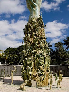
  was now home to 11% of the nationwide American Jewish population who, in turn, made up 12% of the entire county population. Thus it was, that a group of Holocaust survivors formed a committee in 1985 leading to the opening of the Memorial in 1990. The Memorial itself, has a curved walkway with a reflecting pool and a black granite wall from which a passage leads to a circular, walled plaza. The centerpiece of the plaze is a 42-foot bronze arm reaching up out of the ground and decorated with about a hundred life-sized bronze figures, some climbing the arm, some scattered about the plaza. A touch too bizarre, for my simple mind, to evoke much response beyond "Huh?" But then, each to his own.
 In a little over 100 years Miami, Florida grew from 300 people to 5-1/2 million, earning it the title of The Magic City with snowbirders since it seemed to grow magically with each passing year. The place to live of course, is Miami Beach which is confined to the narrow strip of land running down the Atlantic side of the intra-coastal waterway. Miami proper however, has some claims to fame of its
  own. Now the 4th largest metropolitan area in the USA behind New York, Los Angeles and Chicago and the 3rd ranked skyline behind New York and Chicago, Miami has grown into a true southern metropolis. Officially designated a Global City, it effectively fills the area from the Atlantic coast to the everglades along a 40 mile north-south swath. All that aside, downtown Miami is much like any other downtown and the suburbs are a sprawling melee of housing ranging from small, boxy post WWII homes to upscale additions with yuppie villas by the square mile. The only major US city to have been founded by a woman - Julia Tuttle, an early snowbird from Cleveland, incorporated the city in 1896 - its success assured when Ms. Tuttle convinced Henry
  Flagler to extend his railroad south to service the city. Scarily, the entire greater Miami area has a an elevation of just 6 feet above mean sea level. But, our objective was Miami Beach, across the intra-coastal to the southern end of the sandbar known as South Beach. Here is the largest assortment of Deco architecture in the world with almost every example maintained in pristine condition. Conjuring images of pastel colored cruise ships and Flash Gordon
  rocket ships, the Art Deco buildings, with their portholes, rounded walls, steely accents and geometric decorations, are simply awesome. The Art Deco form developed from the 1925 World’s Fair in Paris from a fusion of Art Nouveau and early twentieth century industrial modernism, although the term itself only came into use much later. If you like that sort of thing, click here.
When Frank McCloud (played by Humprhey Bogart) alighted from the bus in Key Largo during the opening scene of the film of the same name, the Overseas Highway,  as US 1 is known, had been operational for less than ten years. From the early 1910's until 1935, outside of a plane or a boat, Henry Flagler's Florida East Coast Railway was the only continuous route to Key West. The 1935 Labor Day hurricane put paid to this convenience in a heartbeat and it wasn't until 1939 or so that a continuous roadway was cobbled up from existing bridges and parts of the defunct railroad. This 127 mile, mainly two lane highway continues to have the highest accident rate per capita, in all of Florida.
Altogether, there are about 1,700 islands in the Florida Keys archipelago, divided into the Upper, Middle and Lower keys. The Saddlebunch keys are a series of mangrove islands in the Lower keys, about 7 miles east of Key West and it is here, on a tiny finger of land, that the Bluewater RV resort is located. See here for more Bluewater views. This particular RV park has 81 total sites, all of which are owned by individuals and, at the time of our stay, almost 25% (20 sites) of these were available as resales - some at quite distressed price levels.
So much for the keys - gone from our to-do list and is unlikely to make our do-again list. Lots of Florida tackiness with few offsetting benefits and, while lurking in the campground was both relaxing and comfortable, there was not more than two or three days of vigorous exploring within an hours drive. Been there, done that.
 Boca Chica Highway, County Road 941 used to run around the southern side of Boca Chica Key. The NAS airfield that now dominates this key was initially constructed in 1940 and, as it has grew and took over the majority of island, the destination for CR 941 was absorbed into the base. Except for the east end of the highway, that serves a surviving residential area, the road has been abandoned and much of it has been recovered by nature.
 Several miles of public right-of-way still run along the shoreline providing a rustic-junkyard quality of beach walk which, half a mile in, is posted "Warning - Clothing Optional Beach Ahead". It was here that we witnessed the true meaning of beach bum as we stumbled naiavely along while assorted buns, lurking in the undergrowth ahead of us, were hurriedly covered. Full story here.
 The Keys do not offer much in the way of shopping. No Wal-Mart, Sam's Club, Costco or elegant malls within 100 plus miles - just a few grocery stores, miles of tacky plazas, lots of bars and a smattering of restaurants. The upscale restaurants in Key West are more convenient than those in Miami a hundred and fifty miles away but are extraordinarily expensive. Such local offerings, at least those that we checked out, are far from stellar.
Ever optimistic, we decided on something different and perhaps, even a little romantic - a Dinner Cruise from which to enjoy a Key West sunset. What a tatty illusion this turned out to be. See sorry story here.
The English guys, Dave and Lynn - they of cool cooking  fame, have a Monaco Dynasty with the Nottingham floor plan. This was the actual coach that wooed us into changing out our Signature last year - all due to the Nottingham's great kitchen. Dave and Lynn sometimes travel with four or five people on board and had the kitchen modified to include an oven and a three burner stove top. An oven! What a joy. We haven't had an RV with an oven since 1991 and, apart from an incendiary episode with the convection microwave in our 2000
  Country Coach, we had put roasts and baking on the road, out of our minds. Now, at the first opportunity we baked some bread and the oven worked like a charm. Next stop was to check out the convection microwave and - Guess what? - it worked like a charm. These loaves were baked on low-mix at 425 for 25 minutes and turned out just right!
 As the weather got colder we kept driving south until there was no more south to go to and still it was cold! That, in a nutshell, is how we ended up huddled around the most southerly point in the lower 48 at the junction of Whitehead and South Streets in Key West, Florida.
While the Keys have always been on our to-do list, the 600 mile journey from the Georgia border through the customary wintertime Florida hordes, coupled with our innate laziness, have always provided ample reason for not bothering. This year however, circumstances ganged up on us and, outside of blatant wimpishness, we simply ran out of excuses. First, we were already at Lazydays having our coach brutalized - a full 1/3rd of the way to the end of the world. Next, some English folk we had met last summer arrived at Lazydays about the same time having booked a site in the keys for a couple of months or so. Finally, with the economy at large holding the populace in some kind of suspended animation, snowbirds were looking like an endangered species and the f ormerly "packed" vacation sites were all replete with vacancies. So, off to Bluwater Keys RV Resort it was!
We greatly enjoyed a couple of weeks lazing around with the Brits, swapping tall tales of the Old Country and petting their adorable 140 pound dog Peppa. Better yet, they turned out to be accomplished meal meisters and we had more cooked meals in two weeks than we normally see in a year! The Bluewater Keys site, chosen from England on a whim, was the best we encountered on the 120 mile ride along the string of mud-piles leading to Key West and, overall, the weather was 60 to 80 degrees warmer than Fort Wayne. All in all, a great trip. See memories of Key West here.
 Christopher Columbus, in 1493, is believed to have been the first European to come across the archipelago that includes what is now Tortola. With typical flair, he named the group Santa Ursula y las Once Mil Vírgenes (Saint Ursula and her 11,000 Virgins) after the legend of Saint Ursula, hence the Virgin Islands. Once squabbled over by the Spanish, British, French, Danish and Dutch as strategic possessions, the islands are now split between the British and the US who bought the few remaining Danish islands in 1917.
The British Virgin Islands (BVI) consist of more than fifty islands,
Christopher Columbus, in 1493, is believed to have been the first European to come across the archipelago that includes what is now Tortola. With typical flair, he named the group Santa Ursula y las Once Mil Vírgenes (Saint Ursula and her 11,000 Virgins) after the legend of Saint Ursula, hence the Virgin Islands. Once squabbled over by the Spanish, British, French, Danish and Dutch as strategic possessions, the islands are now split between the British and the US who bought the few remaining Danish islands in 1917.
The British Virgin Islands (BVI) consist of more than fifty islands, the largest of which, Tortola, contains the capital Road Town. Tortola is approximately 12 by 3 miles and is home to about 18,000 of the total 22,000 population. Although the entire region was a notorious haunt for pirates, the Brits introduced sugar cane which became the main source of foreign trade until the middle of the 1800s. BVI gained separate colony status in 1960 and complete autonomy in 1967.
Since the 1960s, the islands have diversified from an agricultural economy into tourism and financial services with the hugely popular International Business Companies Act, passed in the early 1980s, leading to massive growth in  government revenue. With more than 50,000 companies worldwide having an offshore presence there, the U.S. dollar is the official currency even though the Islands are under the British flag, and BVI residents are amongst the most affluent in the Eastern Caribbean. Affluence of course, is a relative term - the entire Eastern Caribbean exudes an air of abandonment from past Empires and Tortola is no exception. See here for more pictures.
 The hiatus between Thanksgiving and Christmas turned horribly cold in Indiana, motivating us wusses to flee to warmer climes. But where? The most immediate opportunity was a boat to the Antilles, so, without further ado, we left. Big plane to Miami, big boat to eastern Carribean and then sport our lovely legs in shorts for a week or two. Fabulous!
Columbus' first stop in the New World in 1492 was the island of Hispaniola
The hiatus between Thanksgiving and Christmas turned horribly cold in Indiana, motivating us wusses to flee to warmer climes. But where? The most immediate opportunity was a boat to the Antilles, so, without further ado, we left. Big plane to Miami, big boat to eastern Carribean and then sport our lovely legs in shorts for a week or two. Fabulous!
Columbus' first stop in the New World in 1492 was the island of Hispaniola and that was our first port of call as well. Hispanolia (from Spanish, La Española) is about the size of South Carolina and is the second-largest island of the Antilles with Cuba to the west, and Puerto Rico to the east. Today, the western third of the island is home to Haiti while the remainder has become the Dominican Republic. The ship stopped at the little city of Samana on the northeast corner. Click here for more pictures.
 Fria, farta, forte e feia, simply Cold, rich, strong and ugly goes the local Portuguese description for Guarda. A fortified town overlooking the Spanish border about 10 miles to the east, at 3,500 feet Guarda is the highest town in Portugal. Replete with narrow streets, defensive wall and a couple of surviving gates, the highest part of town sports a large square and one of the ugliest Gothic cathedrals known to man. Built in the 14th and 16th centuries, the interior is quite graceful with twisted pillars, arched vaulting and a Renaissance altar of white marble, gilded in the 18th century with 100 high-relief figures. Other churches within the city walls include t
 he Misericordia and São Vicente Church. Sights from around town can be seen here.
Formerly thought to have been a military base for Julius Caesar, then for the Visigoths and eventually for the Moors, modern Guarda was founded in 1199 by the second king of Portugal, Sancho I, has a population of about 31,000 and includes 55 parishes.
he Misericordia and São Vicente Church. Sights from around town can be seen here.
Formerly thought to have been a military base for Julius Caesar, then for the Visigoths and eventually for the Moors, modern Guarda was founded in 1199 by the second king of Portugal, Sancho I, has a population of about 31,000 and includes 55 parishes.
 2008 that is. Since Thanksgiving we have been in a maelstrom. Thanksgiving was at our place with all the US family except Air Force grandson in Wyoming and middle daughter slaving away in England. Turkey (or cook - me) was sub-standard but most everything got eaten anyway so I still claim it as a win.
Then the weather went really bad - cold, cold, cold, so we snuck off to the Caribbean for a while to hasten the onset of Christmas - blogs coming up.
2008 that is. Since Thanksgiving we have been in a maelstrom. Thanksgiving was at our place with all the US family except Air Force grandson in Wyoming and middle daughter slaving away in England. Turkey (or cook - me) was sub-standard but most everything got eaten anyway so I still claim it as a win.
Then the weather went really bad - cold, cold, cold, so we snuck off to the Caribbean for a while to hasten the onset of Christmas - blogs coming up.
Christmas was also at our place, this time with middle daughter but still without USAF grandson. Turkey was great and, after everything was eaten, everyone went home. Funny how that works. Pictures here for the bravehearted.
England daughter went back to the old country so we left town for the winter. So far, made it to Macon, GA but still have not escaped the winter - 31 degrees tonight, quite a hoot this far south to see the locals deal with such frigid times. Monday, the Lazydays' blacksmiths will continue hastening the entropy of our coach as they blunder their way through our punch list. Given that they get done before April we will be heading somewhere, otherwise we'll be heading home. At least there will be a chance to catch up on '08 blogs. Do have a GREAT 2009!
 Burgos, with a population of about 180,000, is the capital of the province of Burgos in the Community of Castilla and Leon. With more ecclesiastical monuments than any other Spanish city, including Toledo, the most precious structure is the Gothic cathedral, which was begun in 1221, and sports features of the 13th to 15th centuries. This awesome building was declared a World Heritage Monument in 1984.
 they were vanquished by the Visigoths in the 5th century. In the 8th century, the Arabs swarmed the entire area before they in turn, were beaten back by Alfonso the Great in the middle of the ninth century.


