 With a population just less than one million, Cologne is Germany's fourth-largest city, after Berlin, Hamburg and Munich. Cologne lies on the River Rhine and is one of the oldest cities in Germany, having been founded by the Romans in the year 38 BC. The famous cathedral is the largest in Germany. Slideshow here.Cologne is also famous for Eau de Cologne, created by an Italian expatriate Johann Maria Farina early in the 18th century. As the fragrance gained popularity, a merchant named Wilhelm Mülhens negotiated the right to use the name Farina, and promptly opened a small factory in Glockengasse. Like oth
 er "hot item"agreements, this one ultimately ended up in court, at which time Wilhelm's grandson Ferdinand Mülhens renamed the product 4711, the house number of the factory in Glockengasse. Both products are still made in the city to this day.
Demographically, Cologne has 100 females for each 95 males and seems to revel in its renown as the "gay capital of the world". Perhaps there is a connection here...
Carnival season is another Cologne biggie, beginning each year on 11 November at 11 minutes past 11 a.m. and continuing, for an entire 3 months or so, until Ash Wednesday. Things apparently really amp up during the last week, when the street carnival starts, it is claimed, with as many as a million people celebrating in the streets on the Thursday before Ash Wednesday. Backstory here.
The landmark cathedral was started in 1248, abandoned around 1560 and finally, finished with a flourish in 1880, to become a German national monument celebrating the newly founded German empire. During the final throes of completion - after 600 plus years of foot-dragging - a large amount of historic heritage was simply torn down, including the city walls, to show the building at its best. During World War II, Cologne was a Military Area Command Headquarters and sustained 262 air raids by the Allies, causing almost 20,000 civilian casualties and effectively razing the city center. During the night of 31 May 1942, Cologne was visited by "Operation Millennium", the first 1,000 bomber raid by the Royal Air Force. 1,046 heavy bombers dropped 1,455 tons of bombs on the city in 75 minutes, killing nearly 500 civilians and rendering a further 59,000 homeless. In 1947, architect Rudolf Schwarz produced a reconstruction plan which took advantage of the sparse remnants of th
 e city center by including several new thoroughfares designed for anticipated automobile traffic. The project also called for the eradication of more than a dozen historical churches and other architectural treasures, exacerbating the destruction of heritage begun in 1880. The reconstruction finally took almost 50 years.The cathedral, officially Hohe Domkirche St. Peter und Maria, is a World Heritage Site and one of the most recognized architectural monuments in Germany. At 478 feet long, 280 feet wide and with two towers, each 520 feet high, it is the largest Gothic church in northern Europe and has the largest facade of any church in the world. For a few years, it was also the tallest structure in the world until being bested by the Washington Memorial in 1884.
 Arnhem is on the Lower Rhine and, since our route into Germany more or less followed the river upstream, we decided that this was our plan and we would follow it further to see where it leads. The Rhineland is a pretty big chunk of western and north-western Germany and only fell into German hands in the early 19th century following one of the collapses of the French Empire, to which it belonged at the time. The southern part is Rhineland-Palatinate while Rhineland-Westphalia is to the north and is the part that borders on the Netherlands. Westphalia includes the Ruhr Valley, the highest population density area of Germany. By and large, this area is the epicenter of the German economic machine and not a particularly popular
  tourist region.
Our journey through the area was somewhat skewed by poor weather but nonetheless, thoroughly enjoyed. We didn't do any walkabouts in the cities along the way mainly because those we looked at had been massively spoiled during WWII and were redolent of hasty, low-cost, post war construction. We did however, continue improving the creature comforts of Penny and generally settling in to our temporary lifestyle. Checkout the Backstories on the Essen and the Cologne campsites and how to pass an inclement climate day in Deutschland.
 The title of the 1977 WWII movie, A Bridge Too Far, actually refers to the bridge over the River Nederrijn (Lower Rhine) in Arnhem, Netherlands. Specifically, the name comes from a comment made by British Lieutenant-General Frederick Browning to Field Marshal Montgomery, the operation's architect, "I think we may be going a bridge too far."
The film approximates the story, and ultimate failure, of Operation Market-Garden, the Allied attempt to break through German lines in September 1944. Despite (or maybe because of) a stellar cast including Dirk Bogarde, James Caan, Michael Caine, Sean Connery, Denholm Elliott, Elliott Gould, Edward Fox, Gene Hackman, Anthony Hopkins, Jeremy Kemp, Laurence Olivier, Robert Redford, Liv Ullmann, Maximilian Schell, Hardy Krüger and Ryan O'Neal the movie was a ho-hum performer at the box office.
An earlier (1946) movie, Theirs Is the Glory, covering the same events, was cast mainly with people who had been involved in the operation and mixed newsreel footage from the actual battle with re-enactments shot on location in Arnhem. John Frost, the British airborne officer and first Allied combatant to arrive in Arnhem, was one of many who played himself in the earlier movie. A thoroughly despicable consequence of the operation's failure was the Hongerwinter (Hungerwinter). In retribution for Dutch railroad workers aiding the allies during the assault, Germany forbade food transportation into the region, utimately starving thousands of Dutch citizens to death.
Anyway, enough cheery banter; time to winge on about Arnhem, 2009. At 114,000 population, one of the largest cities in the Netherlands, there did not appear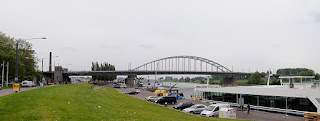 to be a lot going on. Much history of course, was lost in WWII and, outside of a few run down churches and a collection of hideous sculptures, there is little to Ooh and Aah at. Slideshow here.
The post-war utilitarian bridge that replaced the one destroyed in the war, was renamed John Foster Bridge in 1978 although Foster modestly objected. Having seen the bridge he should perhaps, have been more assertive. Campsite Backstory, Arnhem Backstory.
At 16,000 square miles, the Netherlands is about half the size of North Carolina and is home to 16 million people - somewhere between the population of Florida and Illinois. Geographically, it is a low lying country with large areas claimed from the North Sea. More than 10 million of the inhabitants live in the 27% of the country that is actually below sea level. It is not true that windmills are Dutch attempts at helicopters.
 Today, there is serious stuff to do. Must get propane cylinders, shore power cord, big red sign for the bike rack, a roll of anti-skid material for the table and chocolate. As it turned out, all was accomplished with great ease in the suburb of Nieuwegein and we began to feel really secure in our little van, especially now we had chocolate. Although this picture is from Nieuwegein, they had hidden the nice part from our view.
 Nine weeks, eight countries, countless baguettes, three thousand miles of motoring, 250 miles of cycling and 160 of walking, we arrived home from Europe in denial of some serious weight gain. But, what are treadmills for, if not for taking the smile off one's face while prepping for the next outing :o( Meanwhile, we have about 8,000 photographs to organize and connect with the sixty or seventy cities and sights we had the pleasure of visiting, so at least we have a valid reason for lounging around enjoying the Indiana summer.
 "D" for Dutch, that is. Today, we get to run the gauntlet of Swine Flu, as we submit ourselves to that horrifying purgatory, euphemistically marketed as air travel. In my book, there remains not a single redeeming feature of the entire panoply of indignities laughably referred to as jet-setting.
Be that as it may, a one hour trip to Chicago, in zero time (Eastern to Central zone), is our first treat, followed by four or five hours of R&R in that perpetual construction site, O'Hare. Next, a nine hour assault on the senses while risking deep vein thrombosis, claustrophobia and practicing hyper-bladder control. Finally, the thrill of the cattle pens as one is herded at snails pace through immigration, baggage collection and finally customs before being ejected into the swampy terrain surrounding Schipool Airport in the Netherlands.
By then, it will be 21 hours since we last got up and it will be about 9:00 AM in the morn ing with a full day ahead. But, all is not lost, as gradually, we should regain contol of our lives. Just have to get to Rotterdam, find our RV - home for the next nine weeks - get it out of storage, get some gas cylinders, electric power cord, food and water, find out how everything is supposed to work, locate a campsite and collapse in an exhausted stupor.
I can't express how much I am looking forward to Friday morning when, if all goes more or less to plan, I will be free to proudly empty our adorable toilet cassette under the admiring gaze of our fellow campers.
 Horsham is a market town of about 50,000 on the River Arun in the county of West Sussex. The first mention of Horsham was in King Eadreds land charter of 947 CE. The town seems to have grown up around the Carfax, which is nowadays a large, pedestrianized square, complete with a bandstand but was originally a junction of five roads. Like so many mid-sized English towns, Horsham exudes a friendly community atmosphere around this downtown area and supports numerous, well attended activities. See here for pictures.
After leaving Horsham we stopped briefly at the still picturesque village of Cowfold on the final leg of our journey back to Heidi's home in East Sussex. Another hugely enjoyed trundle around Europe was over and we were back to the reality of airlines and schedules as we made our way home to Indiana. This final entry of our 2008 odyssey has ended about 10 months after the event and just in time for the start of our 2009 adventure that begins on April 30th. Watch this space...
 Salisbury is an English cathedral city in the county of Wiltshire, where the rivers Nadder, Ebble, Wylye and Bourne join the Avon, which flows south to the sea. The city's origins can be traced back to the Iron Age and the location was most probably chosen for its abundance of water. The first cathedral, built by St Bishop Osmund between 1075 and 1092, actually at Old Sarum, and was replaced by a larger one on the same site around 1120. Later, the clergy fell out with the military command at Old Sarum and, in 1220, started building a new cathedral a couple of miles away.
Thus began the city of New Sarum, now known as Salisbury. The main body of the church was completed in just 38 years and is considered a masterpiece of Early English architecture. The 400 foot spire, the tallest in the UK, wasn't built until later. The cathedral  contains the best preserved of the four surviving copies of the Magna Carta as well as the oldest surviving mechanical clock in Britain that was installed in 1386.
The new town was laid out in a grid pattern, and by the 14th century, was the foremost town in Wiltshire. The city wall, built in the 14th century, originally had four gates, High Street Gate, St Ann's Gate, the Queen's Gate, and St Nicholas's Gate. A fifth gate was created in the 19th century. Salisbury has been a market town since 1227 and nowadays the market is held every Tuesday and Saturday. Stonehenge is about 8 miles northwest of town and, along with Old Sarum and the original cathedral, the area attracts a lot of visitors. Pictures of Olde England here.
 Our previous three channel crossings had all been between Dover and Calais so, particularly since we were on the Cherbourg Peninsular, we decided to do something different. The route from Cherbourg to Poole is 80 miles - almost four times the Dover-Calais trip - which suggested a lengthy trip. But wait, there is an express ferry that completes the crossing in two hours, slightly quicker than the Dover-Calais trip and with assigned seating to boot - Whoopee! See here for boat ride views.
 Since 2000, Cherbourg has officially been Cherbourg-Octeville, having absorbed Octeville and produced the second largest city (after Caen) in the Basse-Normandie region, with a population of more than 40,000. Prior to the Napoleonic era, Cherbourg had been a comfortable coastal town with a relatively modest natural harbor. Napolean, fearing a British naval incursion, ordered underwater obstructions to be sunk across the harbor entrance which were later fortified with tons of masonry rubble.
Although this work began in a timely manner in 1784, it was not actually completed until 1850, thirty-five years after Napolean got whooped at Waterloo and was sent into exile. The legacy of Bony's paranoia however, led to Cherbourg's development into a major transatlantic port, elevating it to strategic importance during WWII. The Battle of Cherbourg, fought in June 1944 following the Normandy Invasion, ended with the capture of Cherbourg on June 30, by the Allies. Cherbourg is still home to a French Navy arsenal.
Despite generally negative remarks garnered from various reviews and sundry malcontents, we enjoyed a relaxing afternoon poking around town, checking out the old fortifications on the hill to the south and watching activities in the leisurely harbor. More pictures here.
 Pretty much dead center in the Cherbourg Peninsula, Valognes lies directly on the path to a primary Allied objective, a deep water port on the northern tip of the peninsula, Cherbourg itself. The Allied advance, which reached Valognes on June 20th, 1944, was delayed for a while by the massive damage caused by bombardments earlier in the war.
Incredibly however, the town, which is mentioned twice in the movie Saving Private Ryan, still contains a few prime 18th century town houses, despite the worst ravages of two world wars. We camped here overnight in an odd little municipal park. More pictures here.
 Sainte-Mère-Église straddles the N13 road on the Cherbourg peninsula, the major route connecting the D-Day landing zone and Cherbourg. As such, it was a key Allied objective to seize this tiny town from the Germans and thus impede any enemy efforts to send reinforcements from the heavily fortified port.
This task, Operation Boston, fell to mixed units of 82nd and 101st U.S. Airborne Divisions who started dropping on the town as early as 1:40 AM on June 6th, 1944. Heavy casualties were taken, partly due to light from burning building illuminating the paratroopers and making them easy targets for small arms fire. Perhaps the most famous incident of the night involved paratrooper John Steele of the 505th PIR. His parachute caught on the spire of the town church and he spent the night feigning death while dangling there and watching events unfold in the square below. This, and other incidents from the same attack, were woven into the movie The Longest Day.
The outcome was that the town was taken by the early morning of June  6th and tenuously held with small arms until the afternoon of June 7th, at which time tanks and equipment began to arrive from Omaha Beach. Along with several other towns in the area, Sainte-Mère-Église claims to have been the first one to be liberated and with this version of events, it would be difficult to dispute this.
Somewhat belatedly - on November 6, 2007 - Nicolas Sarkozy, President of France, conferred the Legion of Honor medal on six of the US combatants involved in this action. Click here to see dangling paratrooper.
 In November 1972, the commune formerly known as Grandcamp-les-Bains amalgamated with the adjacent village of Maisy forming a new entity of 1,750 people, named Grandcamp-Maisy. Today, Grandcamp-Maisy is an active fishing port, with a fish market, a post office and the inevitable boulangerie.
Back in WWII however, both Grandcamp-les-Bains and Maisy, housed ferocious gun batteries that formed part of Hitler's Atlantic Wall - the intended impregnable coastal defenses against an Allied amphibious attack. The first battery, known as La Martine, was equ ipped with four, 100 mm Czech cannon, with a range of about 6 miles. La Perruque, the second emplacement 1/3 mile to the east, bristled with four, 155 mm French howitzers, with a range close to 7 miles. These French guns, commandeered by the Germans, were actually a holdover from World War I, a quarter of a century earlier. Both sites were protected by mine fields, and anti aircraft emplacements. We stayed overnight in a gruesome campsite right on the ocean or, more accurately, the English Channel. More pictures of this quaint town here.
 The "beaches" - Sword, Gold, Juno, Utah and Omaha - are, of course, where the WWII D-Day landings occurred, starting the liberation of northern Europe. The overall invasion, code named Operation Overlord, began on June 6, 1944 and, on that day alone, a total pf 160,000 men from Canada, the United Kingdom and the United States of America were landed in France. The battle for Normandy continued for more than two months. From the establishment of a foothold in France to the liberation of Paris on 25 August and finally the German retreat across the Seine on 30 August. 2.5 million men, 500,000 vehicles and 8 million tons of supplies poured into the region across these beaches due to the Allies inability to capture a deep water port until Nov
 ember of that year. These staggering achievements were made possible using a Mulberry harbor, a contraption that had been pre-built in sections in England, towed across the channel to Arromanches-Les-Bains, assembled and planted in the ocean floor within a mere three days of the initial assault. This fabricated port, nicknamed Port Winston, was as large as Dover port in England and contained 10 miles of roads, a breakwater system and 33 jetties. Parts of this construction are still visible today. The actual beach visits, like the Curate's Egg, were good in parts. Ranging from crassly aggravating to emotionally overwhelming and some shades in between, Arromanches-Les-Bains was the low point of our day. With ice cream, tee shirts and
  postcard sales obliterating all sense of decorum and respect - a complete disgrace for France and a sobering shock for overseas visitors. At the other end of the spectrum was the Normandy American Cemetery and Memorial. This 170 acre, immaculately kept memory to the 9,387 Americans who lost their lives and the 1,557 Americans missing in action during the Normandy invasion, was a truly stunning, gut-wrenching experience. More pictures here.
 Bayeux, just nine miles from the D-Day beaches, survived WWII essentially unscathed. The Bayeux War Cemetery and Memorial on the other hand, is the largest British WWII cemetery in France, with 3,935 British graves and 466 German, most of them lost in the Invasion of Normandy.A digression. By the middle of the 11th century, England's King Edward had failed to produce an heir, which left an English nobleman named Harold, and William, Duke of Normandy, as the top contenders for the job. Harold, in truth anything but noble, was later captured while fighting in Normandy, and in exchange for his life, promised William that when the King died, he would allow William to have the throne of England. Silly Willy agreed and let Harold go home.
In a while, King Edward did die, and lowlife Harold immediately claimed the throne. Duke William was miffed and, in 1066, promptly took off to England with his army. Fourteen hours later, the Battle of Hastings was over, Harold was dead
Bayeux, just nine miles from the D-Day beaches, survived WWII essentially unscathed. The Bayeux War Cemetery and Memorial on the other hand, is the largest British WWII cemetery in France, with 3,935 British graves and 466 German, most of them lost in the Invasion of Normandy.A digression. By the middle of the 11th century, England's King Edward had failed to produce an heir, which left an English nobleman named Harold, and William, Duke of Normandy, as the top contenders for the job. Harold, in truth anything but noble, was later captured while fighting in Normandy, and in exchange for his life, promised William that when the King died, he would allow William to have the throne of England. Silly Willy agreed and let Harold go home.
In a while, King Edward did die, and lowlife Harold immediately claimed the throne. Duke William was miffed and, in 1066, promptly took off to England with his army. Fourteen hours later, the Battle of Hastings was over, Harold was dead and the Duke added both King-of-England and William-the-Conqueror to his resume. The sweet irony in this, is that many historians believe that if William, the Frenchie, had not won this battle, and hapless Harry had become king, England would not have become the most powerful country in the world and French may have been the official language of the New World. So far, so good! End of digression.
A few years after the Battle of Hastings, Bishop Odo of Bayeux commissioned a work known as Queen Matilda's Tapestry, to be hung in the town's soon-to-be cathedral. From about 1070 to 1080, English nuns crafted a tapestry that is 230 feet long and about 3 feet wide, comprising 58 seperate scenes telling the story of the battle. Meanwhile, the Cathédral Notre-Dame was completed and was consecrated on July 14, 1077, ready for the great work. The Bayeux Tapestry, as it came to be known, is now displayed in a local museum and, by current accounts, remains in excellent condition more than 900 years later. Pics about town here.
 In June 1940, less than a year after the start of WWII, the German army occupied Saint-Lô, a town of 20,000 located on a strategic crossroad in Normandy. Following massive bombing by the American Air Force during the Normandy landings in 1944, the town was estimated to have been 95% destroyed, earning it the dubious title The Capital of Ruins. The damage was so severe by the end of the war, that it was debated whether to rebuild, or simply abandon the place as a memorial.
In the event, reconstruction won out and was begun in 1948. Saint-Lô is now restored to a quiet market town, the capital of the Manche department in Normandy, and surrounded by farms specializing in the breeding of Thoroughbred race horses.One beneficial side effect of the 1944 bombardment was the unearthing of long since buried medieval ramparts overlooking the river Vire, which were also restored. As partial reparations for the destruction of the city, America established the Memorial Hospital in Saint-Lô, which at the time, was the largest hospital in Europe.
Some of the few standing structures at the close of hostilities were the remnants of the 13th to the 15th century Notre-Dame church, its roof and facade destroyed, as well as one and a half of its two towers. The church was patched up during the post-war restoration but remains something of a kludge to this day. An unusual feature of the church that escaped significant damage, is an outdoor pulpit that had been previously saved from demolition in the 19th century, by Victor Hugo. Brief slideshow here.
 Sometimes billed as the 8th Wonder of the World, Mont St Michel is quite astounding. A hunk of granite jutting up from the sand, this former tidal island is about six tenths of a mile off the north coast of France in Normandy. The village built on this rock is literally brimming with cafes, bars and all the usual tasteless tourist tackiness but, the big attraction is the huge abbey perched right on the top - breathtaking! Since at least the 3rd century CE the Mont (then known as Mont Tombe) has been the location for one form or another of religious vessel. By the 11th century, already a major place of pilgrimage, the small chapel atop the rock, began its intermittent growth towards an abbey, commonly
  known as the Merveille or Wonder. The huge Gothic styled structure includes storerooms, a knights hall, a refectory, a chaplaincy and a guest hall. Illustrious visitors over the centuries include Saint Louis, Louis XI, and Francois I. Not everything was plain sailing however, for, as later architects worked on their ever expanding plans, there were several dramatic collapses as the weight of their endeavors
  crushed earlier construction. As if more drama was needed, Mont Saint Michel Bay has the highest tides in Europe - up to 45 feet during the spring tides. The sandy shore has a shallow slope and the sea therefore, recedes as much as nine miles at ebb tide, uncovering huge mussel beds and oyster farms as it goes. A scary aspect of this, put to the test many times each year apparently, is that during the flow tide, the water advances at up to 12 MPH and there are numerous patches of quicksand to negotiate on the way back to dry land. See more pictures here.
 San Malo turned out to be nothing like we expected. Rather than a seaside city with rambling narrow streets, a rich mix of architecture and peppered throughout with a parks and treed squares, we found a uniform set of multi-story, precision built stone buildings, surrounded entirely with massive, crenelated ramparts. So much for romance. Anyway, it is at the seaside, so we were almost right.
Indeed, it seems that the people of Saint-Malo were the first French sailors to sail around the fearsome Cape Horn at the end of the 17th century, and on to exotic places like Chile for nitrate, California or Australia for wood and wheat, New-Caledonia for nickel and so on. More snaps available here.
 The campsite chosen for our visit to St Malo sits on a small promontory above Saint Servan Sur Mer where the Cite d'Alet once was. Standing at the gateway to the river Rance, this area was in use in pre-Roman times as a critical part of the area defense. A bracing walk around the Promenade de la Corniche provides good views of the fortified town and of the Gulf of Saint-Malo. At the highest point of town, close to the campsite, are the remains of the Cathedral of St-Pierre dating from somewhere around 900 CE. The high ground here was used by the Germans, during WWII, as a gun emplacement, the remains of which are now a war memorial. Created in 1994 by the town of Saint-Malo, the 39/45
  Memorial, among other features, has a restored anti-aircraft bunker, built into the ancient fort of the Alet city, with 3 levels and 10 rooms equipped as it would have been during hostilities. Down in the area of Saint Père cove, stands the stalwart Tour Solidor, a fortified building built between 1369 and 1382. Pictures here.
 Dinan had not appeared on our radar and was, therefore, not on our itinerary, until the campground manager at Fourgeres assured us that it was worth a look. From our perspective, he was absolutely correct.
In North East Brittany, this nicely restored, walled medieval town, with a population around 11,000, was indeed a treat. Dinan's history involves ongoing feuds with England, most notably, the Duke of Lancaster’s invasion of 1357. This altercation ended when the local hero, Bertrand Du Guesclin, duffed up the leading English Knight in a one-on one combat. This victory rescued Bertrand's brother from prison and kept the city in French hands. More pictures here.
 With a population just less than one million, Cologne is Germany's fourth-largest city, after Berlin, Hamburg and Munich. Cologne lies on the River Rhine and is one of the oldest cities in Germany, having been founded by the Romans in the year 38 BC. The famous cathedral is the largest in Germany. Slideshow here.Cologne is also famous for Eau de Cologne, created by an Italian expatriate Johann Maria Farina early in the 18th century. As the fragrance gained popularity, a merchant named Wilhelm Mülhens negotiated the right to use the name Farina, and promptly opened a small factory in Glockengasse. Like oth
 er "hot item"agreements, this one ultimately ended up in court, at which time Wilhelm's grandson Ferdinand Mülhens renamed the product 4711, the house number of the factory in Glockengasse. Both products are still made in the city to this day.
  around 1560 and finally, finished with a flourish in 1880, to become a German national monument celebrating the newly founded German empire. During the final throes of completion - after 600 plus years of foot-dragging - a large amount of historic heritage was simply torn down, including the city walls, to show the building at its best. During World War II, Cologne was a Military Area Command Headquarters and sustained 262 air raids by the Allies, causing almost 20,000 civilian casualties and effectively razing the city center. During the night of 31 May 1942, Cologne was visited by "Operation Millennium", the first 1,000 bomber raid by the Royal Air Force. 1,046 heavy bombers dropped 1,455 tons of bombs on the city in 75 minutes, killing nearly 500 civilians and rendering a further 59,000 homeless. In 1947, architect Rudolf Schwarz produced a reconstruction plan which took advantage of the sparse remnants of th
 e city center by including several new thoroughfares designed for anticipated automobile traffic. The project also called for the eradication of more than a dozen historical churches and other architectural treasures, exacerbating the destruction of heritage begun in 1880. The reconstruction finally took almost 50 years.The cathedral, officially Hohe Domkirche St. Peter und Maria, is a World Heritage Site and one of the most recognized architectural monuments in Germany. At 478 feet long, 280 feet wide and with two towers, each 520 feet high, it is the largest Gothic church in northern Europe and has the largest facade of any church in the world. For a few years, it was also the tallest structure in the world until being bested by the Washington Memorial in 1884.


